

The Seasonal Climate Forecast: April to June 2025 Worldwide provides a comprehensive outlook on global weather patterns for the spring and early summer months.
As the world faces a changing climate, this forecast offers critical insights into temperature variations, rainfall trends, and extreme weather events across different regions.
By analyzing current climatic data, atmospheric conditions, and long-term global models, meteorologists can predict key shifts in weather that could impact agriculture, economies, and daily life.
Understanding these projections is vital for governments, industries, and individuals to prepare and adapt to upcoming weather challenges. This report will delve into the anticipated climate phenomena for various regions, helping to guide decision-making and resilience efforts across the globe in the coming months.
Read More: Seasonal Climate Forecast: April to June 2025 Worldwide
Global Seasonal Climate Forecast: April–June 2025
The Seasonal Climate Forecast for April–June 2025 reveals significant shifts in sea surface temperatures (SST) and precipitation patterns, shaping the global climate landscape for the upcoming months.
Sea Surface Temperature Anomalies and Oceanic Conditions
For the April to June period, sea surface temperature anomalies in the Niño 3.4 and Niño 3 regions are expected to decline to near-average levels, signaling a neutral state for the El Niño–Southern Oscillation (ENSO).
In the Niño 4 region, located further west, SST anomalies are also projected to return to near-average conditions. Meanwhile, the Indian Ocean Dipole (IOD) index is forecast to trend toward below-average levels, signaling a shift in the region’s typical climate dynamics.
In contrast, sea surface temperatures in the equatorial Atlantic are predicted to remain above average, both in the northern (NTA) and southern (STA) regions.
Temperature Predictions Across Land Areas
Consistent with the widespread above-normal sea surface temperatures across most oceans—except for the near-equatorial central Pacific Ocean—above-normal temperatures are forecast for nearly all land areas.
Extensive regions with heightened probabilities of above-normal temperatures include much of Africa, Madagascar, Asia, South America (north of 20°S), the Caribbean, Central America, the southern and eastern parts of North America (below 45°N), the western Pacific (west of 160°E), Australia, New Zealand, and Europe.
The regions most likely to experience a significant increase in above-normal temperatures include the Arabian Peninsula extending into Eastern Asia, the Maritime Continent, and a horseshoe-shaped pattern stretching across the North and South Pacific.
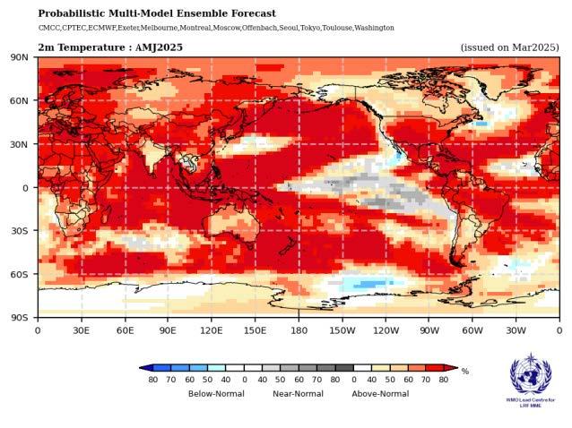
A marked increase in the probability of above-normal temperatures is expected over the region spanning from North and South America, including the Caribbean, northern Africa, and parts of Europe, as well as New Zealand.
On the other hand, the Indian subcontinent, Southeast Asia, and northern and western North American coastal areas are expected to experience a more moderate enhancement in the probability of above-normal temperatures.
Precipitation Patterns and Anomalies
Rainfall forecasts for April–June 2025 reflect a pattern commonly associated with the enhanced positive east-to-west sea surface temperature gradient typically seen during La Niña events, even though the ENSO indices indicate a neutral phase.
Enhanced probabilities for below-normal rainfall are forecasted across regions along and north of the equator, extending from 150°E to 150°W, with a northeastward arch toward southwestern North America. The equatorial region between 150°W and 90°W is expected to experience near-normal rainfall.
Moderate probabilities for above-normal rainfall are predicted over the central and eastern Maritime Continent, with extended regions of above-normal rainfall expected in northern and western parts of Australia and southeastward toward 150°W.
In Africa, rainfall predictions show no clear trends, though isolated areas may experience above- or below-normal conditions. Enhanced probabilities for below-normal rainfall are anticipated across the southern Arabian Peninsula and into Central Asia.
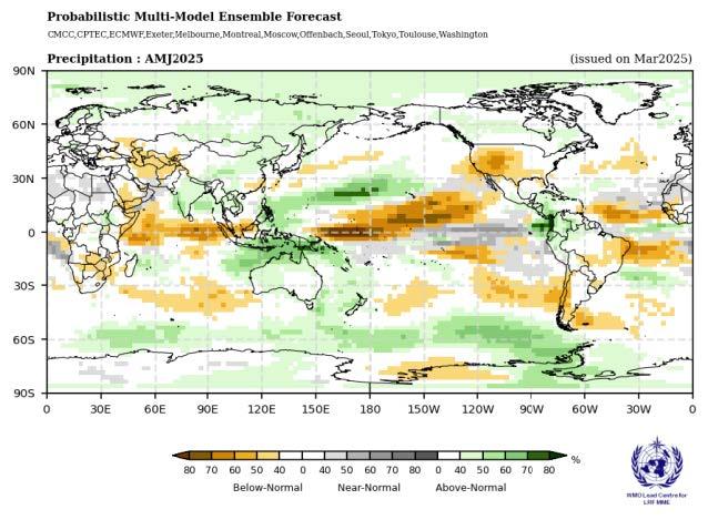
Conversely, the Indian subcontinent, stretching into the Bay of Bengal and Southeast Asia, is likely to experience above-normal rainfall. In North America, a drier pattern is forecast for the interior and southern regions, with a stronger likelihood of below-normal rainfall centered in the southwest.
In South America, above-normal rainfall is expected in the northwest, while the northeast and coastal areas south of 30°S may experience below-normal rainfall. Slightly elevated probabilities for above-normal rainfall are also projected north of 60°N.
Frequently Asked Questions (FAQs)
What is the El Niño–Southern Oscillation (ENSO)?
ENSO is the fluctuation of sea surface temperatures in the Pacific Ocean. A neutral ENSO means typical weather patterns without strong El Niño or La Niña effects.
What does a neutral ENSO state mean for April–June 2025?
A neutral ENSO indicates no major disruptions, leading to more typical seasonal weather patterns, influenced by other factors like regional sea surface temperatures.
How will sea surface temperatures affect the climate?
Warmer-than-average temperatures are expected in the equatorial Atlantic, while neutral SSTs in the Niño 3.4 and Niño 3 regions will contribute to typical global weather trends.
Which regions will experience above-normal temperatures?
Above-normal temperatures are expected in regions such as Africa, Asia, South America, parts of North America, Australia, and Europe.
What are the rainfall predictions?
Expect below-normal rainfall in parts of the equator and North America, while the central and eastern Maritime Continent, Australia, and Southeast Asia may receive more rainfall.
How accurate are these forecasts?
While reliable, forecasts provide general trends and can vary in precision for specific events or localized weather conditions.
Conclusion
The Seasonal Climate Forecast for April–June 2025 highlights a period of neutral ENSO conditions, with varying sea surface temperatures and regional shifts in both temperature and rainfall patterns. While many regions are expected to experience above-normal temperatures, significant rainfall anomalies are also anticipated, with some areas facing drought-like conditions while others may see increased precipitation.