

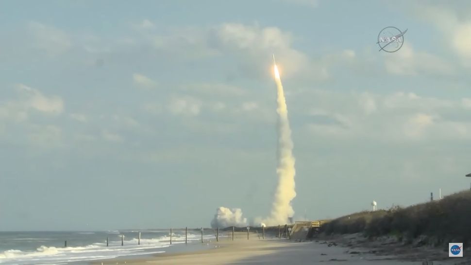
A cutting-edge weather satellite, GOES-S (Geostationary Operational Environmental Satellite-S), launched today, March 1, from Cape Canaveral Air Force Station in Florida aboard a United Launch Alliance Atlas V rocket at 5:02 p.m. EST (2202 GMT).
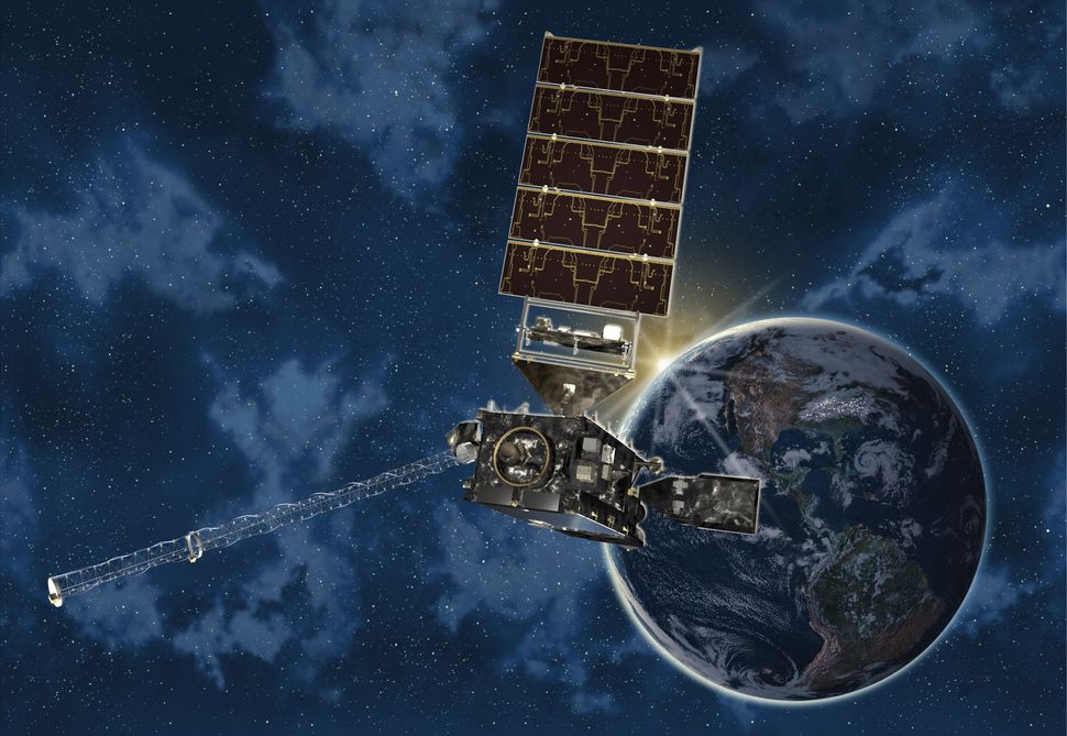
Developed by Lockheed Martin and operated jointly by NOAA and NASA, GOES-S will monitor extreme weather events from a fixed position above the eastern Pacific Ocean.
It is the second in a series of four advanced geostationary satellites designed to provide high-resolution, real-time imagery and atmospheric data.
Together with GOES-East, already in orbit, GOES-S will enhance forecasting capabilities and improve early warning systems for severe storms, hurricanes, and other natural hazards across the Western Hemisphere.
Read More: Next-Gen Satellite Takes Off to Track Severe Weather Events
GOES-S Weather Satellite Launch Marks Major Leap in Forecasting for the Western U.S.
“GOES-S will deliver more precise, high-frequency data to track storm systems, lightning, wildfires, coastal fog, and volcanic ash plumes that affect the western United States, Alaska, Hawaii, and the eastern Pacific,” said Louis Uccellini, director of the National Weather Service at NOAA, during a Feb. 27 news briefing.
“We’ll gain sharper insights into the unique dynamics of Pacific storm systems, significantly enhancing our forecasting capabilities.”Uccellini underscored GOES-S’s role in national preparedness. “Just as GOES-East improved our scientific understanding of the eastern U.S., I believe GOES-S will do the same for the West.
It’s another step toward building a weather-ready nation.”GOES-East, launched in 2016, has revolutionized weather monitoring with unprecedented detail—tracking major storms such as Hurricanes Harvey, Irma, and Maria, as well as January’s bomb cyclone and destructive wildfires in northern Texas.
Now, GOES-S—soon to be renamed GOES-West—will continue that mission with advanced technology.The new satellite scans the atmosphere five times faster than its predecessor, offers four times greater spatial resolution, and uses three times as many spectral bands.
These improvements will give forecasters the ability to track fast-developing threats in near real-time.GOES-S can refresh its full view every five minutes, or deliver imagery from targeted areas as quickly as every 30 seconds to one minute.
When paired with GOES-East, the two satellites will provide rapid, continuous coverage—tracking up to four regions with one-minute updates or two areas with 30-second resolution.
GOES-S Enhances Severe Weather Forecasting with Synchronized Satellite and Radar Observations
Kristin Calhoun, a research scientist at NOAA’s National Severe Storms Laboratory, highlighted the transformative impact of the GOES satellite series on severe weather monitoring during a recent conference.
She noted the enthusiasm within the meteorological community regarding the data from GOES-16 (GOES-East) and the anticipation for the enhanced coverage that GOES-S will provide across the United States.
Calhoun emphasized that, for the first time, geostationary satellite observations and ground-based Doppler radar data are synchronized, enabling the creation of comprehensive, top-to-bottom profiles of severe thunderstorms through direct observation.
This synchronization significantly advances the research, diagnosis, and forecasting of hazardous weather events, offering meteorologists a more detailed and dynamic understanding of storm systems.
The integration of GOES-S into the satellite constellation is expected to further enhance these capabilities, providing improved temporal and spatial resolution for monitoring severe weather phenomena across the western United States.
GOES-S Satellite Enhances Weather Forecasting with Unprecedented Visual Data
During a recent news conference, NOAA and NASA researchers highlighted the transformative impact of GOES-East’s high-resolution imagery on weather forecasting and emergency response.
Notably, during Hurricane Harvey, satellite data enabled first responders to time rescue operations effectively, leading to the safe evacuation of over 200 individuals. Similarly, during California’s wildfire season.
GOES-East provided early detection of fires, allowing authorities to respond promptly even before ground reports were available.
Steve Volz, NOAA’s Director for Satellite and Information Services, emphasized the significance of these visualizations: “The impact of the visualization, the actual videos, the movies coming out is really visceral.
It allows the researchers to see the dynamics in a way that just looking at numbers just doesn’t reveal — the visual impact is remarkable.”GOES-S, launched on March 1, 2018, at 5:02 p.m. EST from Cape Canaveral, is set to join the GOES-R series of advanced geostationary weather satellites.
After a three-week journey to geostationary orbit and approximately six months of instrument calibration and testing, it will assume its position over the eastern Pacific Ocean as GOES-West.
This satellite will complement existing satellites like GOES-East and polar-orbiting satellites such as JPSS-1, launched in November 2017, to provide comprehensive weather coverage.
Louis Uccellini, Director of the National Weather Service at NOAA, underscored the importance of satellite data in modern forecasting: “Every forecast, whether it’s one day, two days, three days, out to seven days in advance, depends on sophisticated numerical models, the world’s fastest computers and a global observing system.
And NOAA’s satellite data provides the backbone for the global observing system, and is the critical element for weather forecasting in the extended ranges. The geostationary satellite, the GOES series, is a crucial component of today’s global observing system.
“The GOES-R program, encompassing four satellites—GOES-R, GOES-S, GOES-T, and GOES-U—has a total lifecycle budget of $10.8 billion, covering development, launch, operation, and decommissioning from 2005 through 2036. The next satellite in the series, GOES-T, is scheduled for launch in 2020.
Frequently A sked Questions (FAQs)
What is GOES-S (GOES-17)?
GOES-S, designated as GOES-17 upon reaching orbit, is a geostationary weather satellite developed by NOAA and NASA as part of the GOES-R series. It provides advanced imagery and atmospheric measurements to monitor weather patterns and environmental hazards across the Western Hemisphere.
When was GOES-S launched?
GOES-S was launched on March 1, 2018, aboard an Atlas V rocket from Cape Canaveral Air Force Station in Florida.
What is the mission of GOES-17?
GOES-17’s mission is to deliver real-time data for weather forecasting, severe storm tracking, and environmental monitoring. It enhances the ability to observe phenomena such as hurricanes, wildfires, volcanic eruptions, and solar activity.
Where is GOES-17 positioned?
GOES-17 is positioned in geostationary orbit at 137.2° West longitude, providing coverage over the western United States, Alaska, Hawaii, and the eastern Pacific Ocean.
How does GOES-17 improve weather forecasting?
GOES-17 provides faster and more detailed observations, allowing meteorologists to track weather systems with greater accuracy. Its high temporal and spatial resolution enhances the detection of severe weather events and improves response times for emergency management.
What challenges has GOES-17 faced?
After launch, GOES-17 experienced issues with its ABI cooling system, affecting the performance of infrared channels during certain periods. Mitigation efforts have been implemented to optimize data quality despite these challenges.
Conclusion
The launch and deployment of GOES-S, now operational as GOES-17, mark a significant advancement in meteorological observation and forecasting capabilities. As the second satellite in NOAA’s GOES-R series, GOES-17 enhances the monitoring of atmospheric conditions, oceanic phenomena, and space weather across the Western Hemisphere .