

Drones are rapidly transforming the field of emergency management, offering innovative solutions to complex challenges. These unmanned aerial vehicles (UAVs) provide real-time data, enhance situational awareness, and enable rapid response in critical situations.
Whether it’s disaster response, search and rescue operations, or assessing damage after a natural catastrophe, drones are proving to be indispensable tools. They can access hard-to-reach areas, provide live video feeds, and deliver crucial supplies, all while reducing risk to human life.
As technology continues to evolve, drones are becoming an integral part of emergency management strategies, revolutionizing the way authorities respond to crises. This article explores how drones are reshaping the landscape of emergency management and the immense potential they hold for the future.
Read More: How Drones are Revolutionizing Emergency Management
Monitoring Hazardous Areas
Emergency drones play a crucial role in enhancing workplace safety by proactively monitoring hazardous environments.
They are frequently deployed to oversee high-risk areas, such as construction sites or industrial zones, where they can detect potential safety hazards and alert workers to take preventive measures.
Additionally, drones are increasingly utilized to inspect critical infrastructure—such as bridges, pipelines, and power lines—allowing for early detection of issues before they escalate into serious safety concerns.
By providing real-time data and reducing the need for human intervention in dangerous conditions, drones are instrumental in mitigating risks and preventing accidents in high-risk industries.
Providing Real-Time Situational Awareness
Drones are invaluable tools for delivering critical, real-time information during emergency situations. In the aftermath of a disaster, drones can rapidly survey the affected area, offering valuable insights into the evolving situation.
This real-time data enables first responders to make informed decisions regarding the most effective course of action. Beyond initial assessments, drones are instrumental in identifying areas of concern—such as collapsed structures, hazardous materials, or obstructed roads.
By providing a comprehensive view of the crisis, this data ensures that resources are directed to the most impacted regions, optimizing response efforts and enhancing overall operational efficiency.
Search and Rescue
Search and rescue operations are inherently risky, often requiring access to dangerous and hard-to-reach environments. Rescue drone technology has significantly enhanced the efficiency and safety of these missions, enabling teams to cover vast areas quickly and locate missing individuals with greater precision.
Equipped with advanced sensors, such as thermal imaging cameras, drones can detect heat signatures even in challenging conditions, while high-resolution cameras and audio equipment provide critical information about the terrain and environment.
This combination of real-time data and aerial mobility allows search teams to make informed decisions, improving response times and increasing the likelihood of a successful rescue.
Delivering Medical Supplies
Emergency response drones play a crucial role in delivering essential supplies during critical situations. These unmanned aerial vehicles can quickly and safely transport medical supplies, food, and other necessities to areas that may be inaccessible by traditional means.
This capability is particularly vital in regions affected by natural disasters, such as floods or earthquakes, where ground transportation may be impeded.
Additionally, drones can deliver life-saving medical equipment—such as defibrillators—to areas with limited access to healthcare services, ensuring timely assistance in urgent circumstances.
Insurance Assessment
Drones offer an efficient solution for surveying damage to buildings, roads, bridges, and other infrastructure following disasters. By capturing high-resolution images, drones provide a comprehensive overview of the affected area, which can be used to accurately assess the cost of repairs or replacement.
This technology enables insurance companies to expedite claims processing, allowing for faster compensation to policyholders while streamlining the overall evaluation process.
Post-Disaster Reconstruction and Recovery
Following a natural disaster, drones facilitate rapid data collection and analysis, enabling efficient post-disaster assessments. Through the creation of 3D models and orthophoto maps, drones help identify damaged areas, assess the severity of the destruction, and inform reconstruction planning.
Additionally, drones are invaluable for inspecting critical infrastructure, such as bridges and power lines, to determine the extent of the damage and ensure these structures are safe for use during recovery efforts.
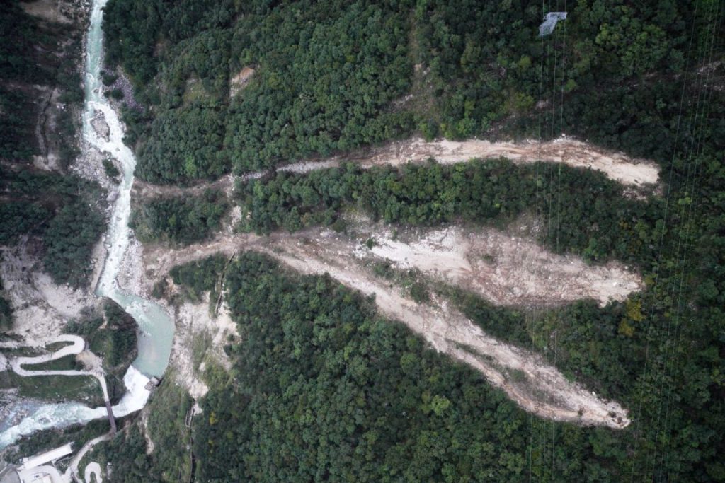
This data-driven approach supports quicker and more informed decision-making in the aftermath of disasters.
Types of Drones Used for Emergency Services
Drones deployed in emergency services vary in design and function, each tailored to specific tasks that enhance response times and operational efficiency. Below are some of the most commonly used types of drones in emergency management:
Multi-Rotor Drones
Multi-rotor drones are the most widely used in emergency response due to their versatility and ease of maneuverability. Their ability to hover in place makes them ideal for capturing high-quality images and video from multiple angles.
These drones excel in close-range operations, such as monitoring disaster sites or conducting search and rescue missions. However, their battery life limits their use for extended surveillance, making them less suitable for long-distance operations.
Fixed-Wing Drones
Fixed-wing drones are optimal for long-range surveillance and large-area monitoring. Their aerodynamic design allows for greater efficiency and extended flight times, enabling them to cover vast areas in a relatively short period.
While they are highly effective for large-scale reconnaissance, fixed-wing drones lack the maneuverability of multi-rotor models and require a runway or launch pad for takeoff, limiting their flexibility in confined spaces.
VTOL (Vertical Takeoff and Landing) Drones
VTOL drones combine the best features of both multi-rotor and fixed-wing designs. They are capable of taking off and landing vertically like multi-rotor drones, allowing them to operate in tight spaces, while also covering long distances efficiently like fixed-wing models.
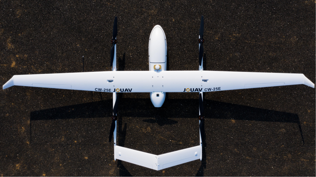
This makes them highly suitable for disaster response and relief efforts, as they can quickly travel over large areas while also hovering in place for detailed observations in hazardous or complex environments.
Critical Drone Features for Emergency Management
Not all drones are suitable for emergency response, and it is essential to understand the key features that make a drone effective in these high-stakes situations. Below are some of the most critical features required for drones used in emergency management:
Durability and Reliability
Emergency situations are unpredictable and often take place in harsh environments. Drones used in these contexts must be built to withstand extreme conditions, including high winds, rain, and low or high temperatures.
Reliability is paramount, as drones must function consistently, even under adverse circumstances, to ensure continuous operation during critical missions.
High-Quality Camera
A high-resolution camera is essential for drones in emergency management. The camera must capture clear, detailed images and videos to assess damage and provide actionable insights.
Additionally, thermal imaging cameras are invaluable for detecting heat signatures, enabling the identification of people or animals in disaster zones, even in low visibility conditions.
Long Flight Time
For emergency management, drones must have extended flight capabilities. A longer flight time ensures that the drone can remain airborne for sufficient periods, allowing responders to gather comprehensive information without frequent recharges or landings.
This feature is critical for large-scale assessments, search and rescue operations, and disaster response.
GPS Navigation
Precise GPS navigation is a must for drones used in emergency management. The ability to fly to specific locations and accurately map areas is essential, especially in GPS-denied environments, such as dense urban areas or disaster sites where signals may be weak.
Reliable navigation ensures that drones can reach and survey key locations without losing direction.
Obstacle Avoidance
Safety is a top priority, and drones equipped with obstacle avoidance systems significantly reduce the risk of accidents. These systems help drones detect and navigate around obstacles such as trees, buildings, and power lines, preventing crashes that could damage the drone or compromise the mission.
Live Video Streaming
Live video streaming is a crucial feature for real-time decision-making in emergency management. This capability enables first responders to view live footage from the drone’s camera, providing immediate insight into the situation on the ground.
It allows teams to adjust strategies dynamically, improving the overall effectiveness of their response.
Ease of Use
Given the high-pressure nature of emergency situations, drones must be user-friendly, even for those with minimal flying experience.
A straightforward, intuitive interface allows first responders to operate the drone quickly and efficiently, minimizing the learning curve and ensuring a fast response when every second counts.
Best Emergency Management Software
In addition to its cutting-edge UAV platforms, JOUAV offers one of the most advanced emergency management solutions available: JoCloud.
As a cloud-based platform, JoCloud seamlessly integrates a variety of data sources, including UAV sensors, ground-based systems, and remote sensing technologies, to provide real-time situational awareness during emergencies.
This data is then processed and analyzed to generate actionable insights, empowering response teams to make informed decisions quickly and efficiently.
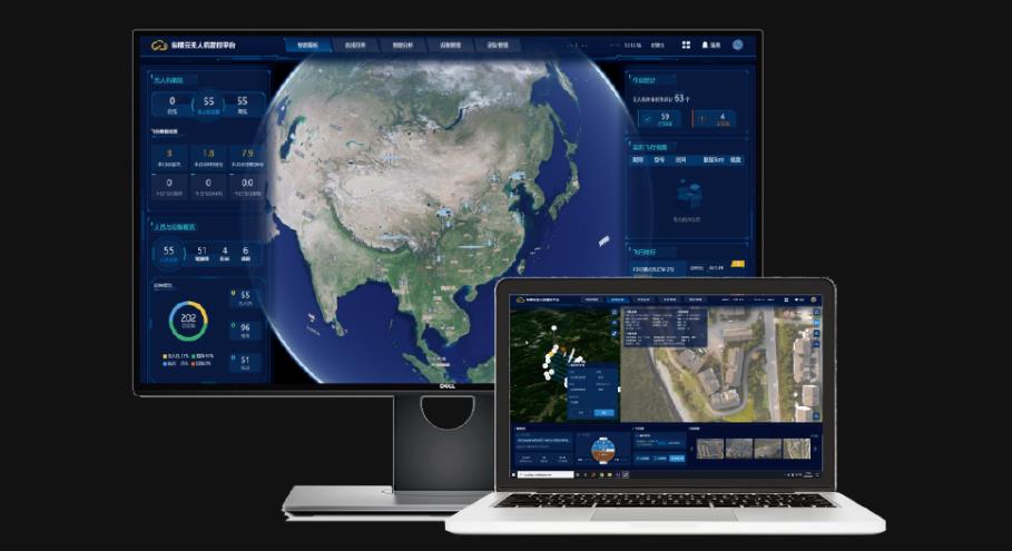
JoCloud enables scalable data storage and processing, ensuring that real-time analysis can be conducted without delay.
The platform also facilitates collaboration among multiple stakeholders, such as emergency responders, government agencies, and non-governmental organizations (NGOs), who can access the same data in real time and coordinate their efforts to respond to the crisis more effectively.
Frequent Asked Question (FAQs)
How do drones help in emergencies?
Drones provide real-time situational awareness, assist in search and rescue, deliver medical supplies, and assess damage in hard-to-reach areas.
What types of drones are used for emergencies?
Multi-rotor drones for close-range operations, fixed-wing drones for long-range surveillance, and VTOL drones for versatility in both.
What are the essential drone features for emergencies?
Durability, high-quality cameras (including thermal), long flight time, GPS navigation, obstacle avoidance, live video streaming, and ease of use.
Can drones deliver medical supplies?
Yes, drones can transport medical supplies and essentials to disaster-affected areas.
How do drones assist in search and rescue?
Drones use thermal imaging and high-resolution cameras to locate missing persons in hazardous environments.
What is JoCloud?
JoCloud is a cloud-based platform that integrates UAV and sensor data to provide real-time insights for emergency response teams.
Conclusion
Drones have emerged as a transformative tool in emergency management, offering a wide range of capabilities that enhance the effectiveness and efficiency of disaster response efforts. From providing real-time situational awareness and conducting search and rescue missions to delivering vital medical supplies and aiding in post-disaster recovery, drones are revolutionizing the way emergencies are managed.