

The Pacific Ring of Fire is one of the most geologically active regions on Earth—and it’s as fascinating as it is dangerous. This horseshoe-shaped zone stretches around the edges of the Pacific Ocean, touching countries like Japan, Indonesia, the United States, and Chile.
What makes it so threatening? It’s home to over 75% of the world’s active and dormant volcanoes and experiences about 90% of the planet’s earthquakes. Tectonic plates constantly collide, shift, and grind beneath the surface, building pressure that can unleash devastating natural disasters.
From volcanic eruptions to tsunamis and massive quakes, the Ring of Fire isn’t just a name—it’s a real-time reminder of the Earth’s raw power. Understanding its dynamics is crucial for predicting and surviving future events.
Read More: What Makes the Pacific Ring of Fire So Dangerous?
The Geological Marvel: What Exactly Is the Pacific Ring of Fire?
Contrary to its name, the Pacific Ring of Fire is neither a hit song by Johnny Cash nor a perfectly circular formation. Instead, it is a vast, horseshoe-shaped belt encircling much of the Pacific Ocean, renowned for its intense seismic and volcanic activity.
This dynamic zone is where several of Earth’s tectonic plates meet, collide, and shift—triggering frequent earthquakes and explosive volcanic eruptions.
Spanning an astonishing 25,000 miles, the Ring of Fire includes a dense network of mountain ranges, fault lines, oceanic trenches, and over 75% of the world’s active volcanoes.
It stretches from New Zealand, along the eastern rim of Asia, across the Aleutian Islands of Alaska, and down the western coasts of North and South America.
The result? One of the most geologically volatile regions on the planet.To better understand the reach and significance of this seismic corridor, consult a Ring of Fire map that visually outlines its trajectory and scope.
Which Countries Are Located Along the Pacific Ring of Fire?
Several countries lie within or near the Pacific Ring of Fire, making them particularly vulnerable to earthquakes, volcanic eruptions, and tsunamis. Among the most at-risk nations are the western United States, Chile, Japan, and various Pacific Island nations, such as the Solomon Islands.
In addition, other countries located within this volatile seismic zone include Indonesia, New Zealand, Papua New Guinea, Canada, Guatemala, Russia, Peru, Mexico, and even parts of Antarctica.
These regions are exposed to persistent geological threats due to their proximity to active tectonic boundaries and fault lines.
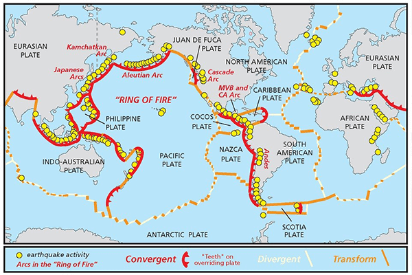
Which Tectonic Plates Form the Pacific Ring of Fire?
Often referred to by geologists as the Circum-Pacific Belt, Rim of Fire, or the Girdle of Fire, the Pacific Ring of Fire traces the collision zones of numerous tectonic plates. These include the Pacific Plate, North American Plate, Juan de Fuca Plate, Cocos Plate, and several smaller microplates.
The dynamic interactions among these plates—subduction, collision, and sliding—are responsible for the intense seismic activity that characterizes this region. The movement of these plates shapes the geological landscape and influences the frequency of natural disasters in surrounding countries.
What Type of Plate Boundary Defines the Ring of Fire?
The Pacific Ring of Fire is primarily defined by convergent and transform plate boundaries. According to National Geographic, a transform boundary occurs when tectonic plates slide past one another horizontally.
At these friction zones, portions of the plates can become locked, causing stress to accumulate until it is violently released as an earthquake. These fractures in the Earth’s crust are known as faults, and many of the world’s most active fault lines are located along the Ring of Fire.
A prominent example is the San Andreas Fault in California, one of the most closely monitored faults in the world.
This transform boundary lies between the Pacific Plate (moving northwest) and the North American Plate (moving southeast), forming a highly active seismic zone that is integral to the overall structure of the Ring of Fire.
How Did the Pacific Ring of Fire Form?
The formation of the Pacific Ring of Fire is a direct result of tectonic plate movement, according to National Geographic. Earth’s outer shell is divided into large plates—massive slabs of crust and upper mantle—that constantly shift over a semi-fluid layer called the asthenosphere.
These movements cause plates to collide, diverge, or slide past one another, particularly around the Pacific Basin.One of the primary mechanisms driving the Ring of Fire’s formation is subduction—a process where one tectonic plate is forced beneath another.
As a plate descends into the Earth’s mantle, it melts and generates magma, which can rise to form volcanoes. The Ring of Fire has developed over millions of years, shaped by the evolution of numerous subduction zones.
Why Is It Called the Pacific Ring of Fire?
The name “Pacific Ring of Fire” derives from the high concentration of active volcanoes that line the Pacific Ocean in a loop-like shape. Though not a perfect circle, this 25,000-mile-long zone resembles a horseshoe, and it contains approximately 75% of the world’s volcanoes.
The term “fire” refers to the frequent volcanic eruptions and seismic events caused by the intense geological activity along these tectonic boundaries.
Why Is the Ring of Fire Important?
The Pacific Ring of Fire plays a critical role in Earth’s geological dynamics. It is the epicenter of most global seismic and volcanic activity and houses the world’s deepest ocean trench, the Mariana Trench.
The region’s intense geological phenomena provide scientists with vital insight into earthquake behavior, volcano formation, and tectonic processes. Understanding this volatile zone is essential for predicting natural disasters and mitigating their impact on nearby populations.
How Many Volcanoes Are in the Ring of Fire?
According to the National Oceanic and Atmospheric Administration (NOAA), the Ring of Fire is home to more than 450 volcanoes.
These represent a significant portion of the world’s active volcanoes and stretch from South America’s southern tip, up along the west coasts of North America, across the Aleutian Islands, and down through Japan, Southeast Asia, and into New Zealand.
What Are the Most Notable Volcanoes in the Ring of Fire?
Several iconic volcanoes define the landscape of the Ring of Fire. Among them are:
- Mount Fuji – Japan’s tallest and most iconic mountain
- Mount St. Helens – Washington State, USA, known for its catastrophic 1980 eruption
- The Andes Range – Featuring numerous volcanoes in Chile, Peru, and Argentina
- Krakatoa – An infamous island volcano in Indonesia
- Mount Ruapehu – One of New Zealand’s most active volcanic peaks
- The Aleutian Islands – A chain of volcanic islands in Alaska
These volcanoes are not only geologically significant but also pose ongoing threats to surrounding communities due to their explosive potential.
What Is the Most Dangerous Volcano in the Ring of Fire?
While many volcanoes within the Ring of Fire are active, a select few stand out as particularly hazardous. According to volcanologist Dr. Heather Handley, five of the most dangerous volcanoes in this region include:
- Mount Agung – Indonesia
- Mount Sinabung – Indonesia
- Mount Mayon – Philippines
- Mount Kadovar – Papua New Guinea
- Mount Kusatsu-Shirane – Japan
These volcanoes are closely monitored due to their frequent eruptions, proximity to dense populations, and potential for large-scale disasters.
Why Do Earthquakes Frequently Occur Around the Ring of Fire?
The Pacific Ring of Fire is one of the most geologically active regions on Earth, and for good reason. Stretching across a vast expanse of the Pacific Ocean, this horseshoe-shaped zone is characterized by the convergence of multiple major tectonic plates.
According to Britannica, this area is under constant geological stress due to the collision, subduction, and lateral movement of these plates.
As a result, the Ring of Fire is responsible for the majority of the world’s seismic activity. Frequent interactions at plate boundaries trigger powerful earthquakes, making this region highly prone to both minor tremors and catastrophic seismic events.
The presence of hundreds of active volcanoes further adds to the instability of the region, heightening the risk of natural disasters.
How Many Earthquakes Occur in the Ring of Fire?
It is estimated that approximately 90% of the world’s earthquakes originate within the Pacific Ring of Fire. Additionally, the region is home to 75% of the planet’s active volcanoes, making it the most dynamic and hazardous seismic zone on Earth.
Some of history’s most devastating natural disasters have occurred along this volatile arc. Notable examples include:
- The 1960 Great Chilean Earthquake, the most powerful earthquake ever recorded
- The 2004 Indian Ocean tsunami, triggered by a massive undersea earthquake
- The 2011 Tōhoku earthquake and tsunami in Japan
- The 1883 eruption of Krakatoa, one of the most violent volcanic events in recorded history
Each of these catastrophic events was rooted in the tectonic activity that defines the Ring of Fire.
How to Prepare for a Ring of Fire Earthquake in California
California’s location along the Pacific Ring of Fire, coupled with the presence of the San Andreas Fault—an 800-mile-long transform fault that runs from Southern California through the Bay Area—places the state at constant risk of a major earthquake. Preparedness is not optional; it’s essential.
Homes built before 1980 are particularly vulnerable if they haven’t been seismically retrofitted. These structures were often constructed before modern building codes accounted for earthquake resilience, leaving them susceptible to severe structural damage or collapse during strong ground shaking.
To safeguard your home and family:
- Retrofit older homes to meet current seismic standards
- Secure heavy furniture and appliances to walls
- Create an emergency plan and stock up on essentials such as water, food, medications, and first aid supplies
- Stay informed about local seismic risks and updates from emergency services
Frequently Asked Questions (FAQs)
Why do earthquakes frequently occur around the Ring of Fire?
The Ring of Fire is home to several major tectonic plate boundaries where plates collide, slide past, or move apart. These movements generate intense geological pressure, often releasing energy in the form of earthquakes. This tectonic activity makes the region one of the most earthquake-prone areas in the world.
How much of the world’s earthquake activity happens in the Ring of Fire?
Approximately 90% of the world’s earthquakes occur within the Ring of Fire. The region is also responsible for 75% of all volcanic activity globally, highlighting its extreme geologic volatility.
What is the San Andreas Fault, and why is it important?
The San Andreas Fault is one of the most active faults in the Pacific Ring of Fire. It stretches approximately 800 miles through California and marks the boundary between the North American Plate and the Pacific Plate. It is a transform fault, where the plates slide past each other horizontally, making it a major source of earthquakes in California.
What is the Ring of Fire’s overall significance?
Beyond its potential for natural disasters, the Ring of Fire plays a crucial role in advancing our understanding of plate tectonics, earthquakes, and volcanic activity. It helps geologists and emergency planners develop better strategies for disaster preparedness and mitigation.
What is the Ring of Fire and where is it located?
The Pacific Ring of Fire is a horseshoe-shaped zone encircling the Pacific Ocean, spanning over 25,000 miles. It includes the coastlines of countries such as the United States, Chile, Japan, Indonesia, New Zealand, and others. This region is characterized by a high concentration of volcanoes, earthquakes, and tectonic plate boundaries.
Why is it called the “Ring of Fire”?
The name stems from the over 450 active volcanoes that encircle the Pacific Ocean basin. These volcanoes form a “ring” of intense geothermal and seismic activity, giving rise to the term “Ring of Fire.” Despite the term “ring,” the structure is more of a horseshoe shape than a perfect circle.
Conclusion
The Pacific Ring of Fire stands as one of the most geologically dynamic and scientifically significant regions on Earth. Spanning thousands of miles and encompassing the edges of multiple continents, this seismic zone is responsible for the vast majority of the world’s volcanic eruptions and earthquakes. Formed through the constant movement and interaction of tectonic plates, the Ring of Fire serves as a natural laboratory for geologists, seismologists, and volcanologists working to better understand the forces that shape our planet.