

Next-Gen Satellite Takes Off to Track Severe Weather Events” enhances forecasting with advanced imaging and real-As spring arrives, bringing warmer temperatures and longer days, nature begins to bloom across much of the United States.
However, the season also brings an increased risk of severe weather, including tornadoes, large hail, flash floods, and damaging winds. With these heightened threats come a surge in weather alerts, primarily in the form of watches and warnings.
While both signals of impending danger, they are distinctly different — particularly in terms of the actions you should take when the forecast takes a dangerous turn.Spring conditions are particularly conducive to severe weather, with storms occurring more frequently and with greater intensity.
Understanding the difference between a watch and a warning can be crucial in responding appropriately to these potentially life-threatening situations.time data.
Read More: What’s the Difference Between Watches and Warnings, and Which Weather Alert is More Severe?
Understanding the Difference Between a Watch and a Warning
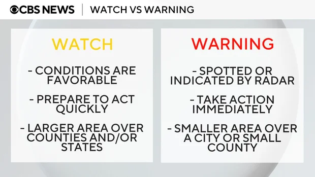
A watch is typically issued by the National Oceanic and Atmospheric Administration’s Storm Prediction Center (SPC) hours before a potential storm system. Its purpose is to alert individuals in affected areas to closely monitor weather conditions and stay informed about updates.
Watches cover larger regions, often extending across multiple counties or even states. Whether it’s a severe thunderstorm watch or a tornado watch, the key message is to remain vigilant and be prepared to act quickly.
On the other hand, a warning is issued when severe weather has been confirmed, either through eyewitness reports or radar detection. This type of alert is more urgent and requires immediate action.
Warnings are usually confined to smaller, more specific areas, such as a city or county.
For instance, if a tornado warning is issued for your area, you should immediately seek shelter in the lowest level of a building, preferably in the most interior room, with as many walls between you and the outdoors as possible.
Always cover your head to protect yourself from flying debris.Regardless of the type of alert, it’s crucial to take all weather warnings seriously and be prepared to take swift action when severe weather is imminent.
How Meteorologists Monitor Severe Weather
Specialists at the National Oceanic and Atmospheric Administration’s (NOAA) Storm Prediction Center (SPC) play a critical role in identifying and forecasting severe weather events across the United States.
These experts issue outlooks and alerts that can provide valuable advance notice, sometimes up to eight days before a storm develops.
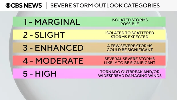
To assess the potential severity of thunderstorms, the SPC uses a five-tier rating system, ranging from Level 1 (Marginal)—indicating isolated, less intense storms—to Level 5 (High), which signals the potential for widespread, destructive winds or a significant tornado outbreak.
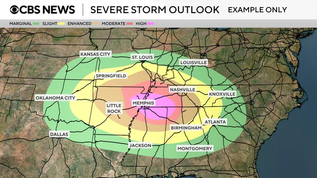
Severe weather outlooks, typically displayed as color-coded regions on a U.S. map, are based on detailed forecast models. These maps are designed to show where severe conditions may develop and are updated regularly as new data becomes available.
Meteorologists carefully analyze these forecast models, examining key atmospheric ingredients that influence storm formation. This includes tracking moisture levels, cold fronts, and wind shear—factors that significantly affect a storm’s development and intensity.
They also assess storm speed and structure to determine not only where an outbreak may occur but also how severe it might be.
Frequently Asked Questions (FAQs)
What is the difference between a weather watch and a weather warning?
A watch indicates that conditions are favorable for severe weather to develop. It serves as a heads-up to stay alert. A warning means severe weather is already occurring or is imminent, and immediate action should be taken to ensure safety.
Who issues weather watches and warnings?
Watches are typically issued by the NOAA Storm Prediction Center (SPC), while warnings are issued by the local National Weather Service (NWS) office closest to the affected area.
How far in advance can meteorologists predict severe storms?
The SPC can issue severe storm outlooks up to eight days in advance. These forecasts are updated frequently based on the latest model data and atmospheric conditions.
What should I do during a tornado warning?
Immediately move to the lowest level of a sturdy building, ideally a basement or interior room without windows. Put as many walls between you and the outdoors as possible and cover your head and neck.
Are watches and warnings issued for other types of weather?
Yes. Watches and warnings can be issued for a range of severe weather, including thunderstorms, tornadoes, floods, hurricanes, and winter storms.
How do meteorologists determine where to issue watches or warnings?
They use forecast models to analyze moisture levels, temperature contrasts, cold fronts, wind shear, and other key atmospheric indicators. This helps them predict where severe weather is most likely to occur and how intense it may be.
Conclusion
As spring ushers in warmer temperatures and longer days, it also heightens the potential for severe weather events like tornadoes, hailstorms, and flash floods. Understanding the difference between a watch and a warning is essential for staying safe. A watch signals that conditions are favorable for severe weather, urging you to stay alert and prepared. A warning, on the other hand, means the threat is real and immediate action is necessary.